Map
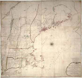
Map of the Four New England States, by Norman and Coles
| Date: | 1785 - 1785 |
| Creator: | John Norman |
| Publisher: | Norman & Coles |
About this artifact
This early wall map of the four New England states of Massachusetts, New Hampshire, Connecticut and Rhode Island was published in 1785. At that time, Massachusetts encompassed what would in 1820 become the state of Maine, and New Hampshire included some Vermont counties.
Courtesy Norman B. Leventhal Map Center at the Boston Public Library, Boston, MA Norman B. Leventhal Map Center
| Print | Top of Page